
(Update on 2/1/2018: I finally decided to finish and publish this private blog post about handling the uncertainties in the ice jam modelling of HEC-RAS software. The reason to do this on a holiday day is a new HEC-RAS River Ice Modeling forum, which was just founded on the already excellent HEC-RAS help forum.)
River ice breakup jams may cause significantly high water elevations. In some regions they may be the only source of floods in terms of flooding outside the river banks. If it is challenging to obtain all the information for an open water flood (i.e. without ice), it surely is the case with river ice. In addition to the basic data (discharge, downstream water elevation, Manning’s roughness coefficients) river ice simulations in HEC-RAS require for example the following information:
- the location of the ice jam toe
- ice jam and solid ice cover roughness (Manning’s n)
- cross section range where the ice jam is allowed to form up
- several ice jam parameters like porosity, maximum under ice velocity, friction angle, K1 stress ratio etc.
Now, a very good question is, that are you in the first place able simulate a single “representative” ice jam scenario by just locking the parameters with single and default values? By doing so at least I, as a modeller, would be really hesitant to give the customer a reliable estimation about the ice jam probability or the damage potential of the ice jam flood. As each winter and ice breakup event will have a different discharge, ice jam formation location, downstream water elevation and ice volume contributing the ice jam, it would be quite dangerous to lock yourself up with a single parameter set. Neither can we be sure about the correctness about the model’s default values for the ice cover parameters. And it is always a good practice to clarify the uncertainties in your modelling project anyway.
..especially when there is a way to do this efficiently in HEC-RAS! You can use VBA code to change the HEC-RAS parameters. This can be done by using the HECRASController API or semi-automatically to modify the source HEC-RAS files (geometry file, boundary condition file and simulation plan file). I did the latter with VBA – as I couldn’t figure out how to manage the varying location of the ice jam toe and allowed ice jam length. The results were however dug out of the hundreds of simulations by the help of Chris Goodell‘s amazing book, where the usage of HECRASController is covered in detail.
The basic idea is to define each parameter a typical range, generate hundreds of parameter combinations and then perform the simulations and analyse the results. It is unnecessary to mention, that local knowledge and observations are a crucial help in this work. The amount of data is huge in this method, but with some automation it will not take much more time compared to old fashioned single-parameter-modelling. As a result you will get a more confident picture about the significance of each parameter. Some parameters are of course obvious (like the amount of ice in the ice jam), but the ice jam location, downstream water elevation and discharge may cause varying effects thorough the river reach. Further work is still needed for example in handling the joint probability of discharge and sea water level.
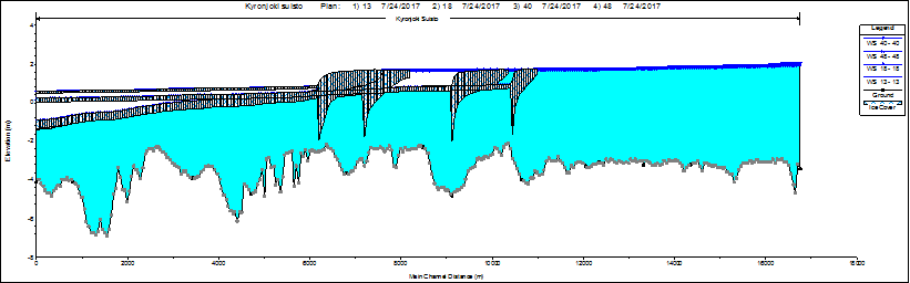
For example in a river profile picture below you can see how the same flood water elevation in the upstream may be achieved with very different sea level elevations, ice jam locations and ice volumes. Discharge can’t be seen on these profiles, but that varied a lot as well.
Results may be also taken into a more abstract level like “point clouds” below. I got a lot of inspiration for these point cloud figures from professor Keith Beven’s generalized likelihood uncertainty estimation (GLUE) papers. I can highly recommend his books and papers around uncertainty estimation. Each little picture below contains the same amount of water elevations (n=936) but they are presented against different parameter or boundary condition.

This HEC-RAS method has been applied for four Finnish rivers when it comes to ice jams. As the method is of course capable of simulating the corresponding open water situation, you can use this to obtain rating curves for lake outlets without any real or insufficient observations. But back to floods: Water elevations can be further refined into flood inundation maps, where the parameter uncertainty is taken into account. An example of this is presented below:
![]()
I presented a project covering this method in the 19th CRIPE workshop in Whitehorse, Canada. I think I have never been so nervous to give a presentation as the quality of the workshop was so high and there were the best river ice experts and gurus in the audience. I was glad (and relieved) to receive positive feedback and people encouraged me to continue with this topic. I highly recommend the CRIPE workshops for anyone interested in river ice research. There were not too many of us from Europe.
The project by the way is a joint project between Finnish Environment Institute and Centre for Economic Development, Transport and the Environment for South Ostrobothnia. The river ice breakup modelling is a part of a larger entity around developing the estuary of River Kyrönjoki. There is a great blog post (in Finnish) about the entity in here. At the moment we have done the simulations for the current river bed and identified some interesting locations to where some modifications will be applied. We will apply the model geometry and run the same simulations again and see if the alterations have any significant and cost-effective benefits.
Below is my CRIPE 2017 presentation about river ice breakup modelling and how we took the uncertainties account:
We also wrote a conference paper about this. A direct link to our paper is here and the complete proceedings of the workshop can be found here.
Do you have any questions, comments or suggestions for this topic? Have your say in the comments below, please!
Nice and interesting work. Something to think of for our Norwegians River also.
Very nice blog post! Thanks Juha!
CRIPE workshops are very interesting events indeed. Our paper around the same subject from CRIPE 2015 can be found here: http://cripe.ca/docs/proceedings/18/22_Ahopelto_et_al_2015.pdf
But you have improved the method much further from there.
BTW, here are some more photos probably from the same day as your photo ( https://photos.app.goo.gl/Y3Y9sDTOXlR3we223 ). Nothing to do with river ice breakup, but at least river ice and elevating water. 😉